Maps
Click on the pictures to make them larger.
This map is from the McDowell Mountain Park Trailhead
Gateway Loop Trail to Inspiration Point and back
This map shows Gateway Loop Trail without Windgate trail to Inspiration Point. This map does not have Desert Park Trail either.
This map shows Gateway Loop Trail, Windgate Pass (without going to Inspiration Point) and back down Desert Park Trail to the trailhead.
John, Tim and Nancy prehiked this trail on April 1, 2022. It was a very hot day so it was hard to evaluate what it would be to hike in January. There are several ways we could hike this trail. The medium group could start on Saguaro Trail then turn right onto Gateway Loop trail to go counterclockwise on the Gateway Loop Trail and back to the trailhead. The first half of the loop is rated as moderately difficult, and the second half is rated as easy. There could be an added 1.1 mile by going on Horseshoe Trail back to the traihead. Horseshoe Trail is flat. This would make the hike 4.7 miles. This sounds like a short hike, but the first half of Gateway Loop Trail has loose rock and slows the pace. 3.6 miles without Horseshoe trail. 4.7 miles with Horseshoe trail.
Another way the medium group could hike this trail is to start at Saguaro Trail then turn left on Gateway Loop Trail to go clockwise on Gateway Loop Trail and keep going up Windgate Pass Trail to Inspiration Point. This would provide a nice viewpoint and place to eat lunch for this group. This would then be an out and back hike, about 5.2 miles. This would cut off the part of Gateway Loop Trail that is rocky. This hike could include the Horseshoe Trail at the end adding 1.1 miles making it 6.3 miles.
The long hikers could go to Saguaro Trail and turn right onto on Gateway Loop trail (going counterclockwise), then go up Windgate Pass Trail to Inspiration Point for Lunch. They could take Desert Park Trail from a junction on Windgate Pass Trail (6.7 miles) or complete the loop of Gateway Loop Trail (5.4 miles). If they took Gateway Loop Trail, they could add mileage by going 1.1 miles back to the trailhead on Horseshoe trail:7.8 and 6.5 miles total.
Summary of both long hikes:
Long hike - Desert Park Trail - Saguaro to Gateway loop Counterclockwise to Inspiration point (via Windgate Pass) and down Desert Park Trail off of Windgate Pass Trail = 7.8 miles
Long Hike - Desert Gateway Loop - Saguaro to Gateway Loop Counterclockwise to Windgate Pass to Inspiration Point and completing Gateway Loop with Horseshoe Trail = 6.5 miles.
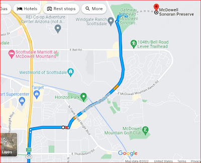
Directions to McDowell Sonoran Preserve, Gateway Trailhead.
Take I-10 West to exit 161 onto Loop 202 and go to exit 50A and onto Loop 101. Go to exit 39 and turn right onto Raintree Drive. Travel 0.7 miles and turn left onto North Thompson Peak Parkway. Go 2.6 miles and look for the entrance to the park, which is not well marked. (It is 0.5 miles north of Bell Road, on the right.) It is 62.5 miles and took 1:15.
There are washrooms, water and ample parking at the trailhead.
John and Tim starting on Saguaro Trail toward Gateway Loop Trail
Still on Saguaro Trail
Junction of Saguaro Trail and Gateway loop trail. We went counterclockwise (to the right).
This is the junction of Gateway Loop Trail and Windgate Pass Trail
It was very hot so we stopped in the shade.
Inspiration Point
Just past Inspiration point on Windgate Pass Trail
Going back down Windgate Pass Trail
Sign from Windgate Pass Trail to Desert Park Trail (one that Long Hike may choose to take)
Sign showing the trailhead
Back To Trailhead


.jpg)
.jpg)
.jpg)


_4.jpg)

_30.jpg)


_5.jpg)


.jpg)


