December 13, 2022
It was cool today at San Tan Mountain Park. John and I drove to the park by going Attaway Road to W. Hunt Highway, then turning right onto Greg Drive. This took us into a subdivision and eventually to Phillips Road that leads into the park. We checked out Thompson Road, but there was construction.
It costs 7:00 per car to get into the park. There was ample parking and clean washrooms. There will be a horse event on Friday, but it shouldn’t affect our hiking group.
We walked around the tortoise habitat and memorial area before heading to the Goldmine trail.
This trail is wide and flat at the beginning, then heads up into the mountains. There is a hazardous sign ½ way up the trail, showing loose rock on steep inclines. Hikers need good hiking shoes for grip. At the saddle, there is a steep, rocky trail to the top of a viewpoint; but it is off-limits.
From the saddle, we could see the other trailhead and signs of overburden from a mine. We started down the rocky and steep trail.
Several people on the trail told us which way they preferred to hike. Some liked to hike up the steep side first, but we would have to come from the N. Wild Horse Drive Trailhead (described below). One hiker told us about a bench their family had donated for their seventy-eight-year-old father who likes to hike this trail. He can now sit and enjoy the view.
When we came to the junction of Goldmine and Dynamite, a trail leads to another trailhead where we can use the Porta-Potty washrooms. This trailhead can be accessed turning left off W. Hunt Road to Empire Blvd. and left onto N. Wild Horse Drive.
Back on the trail, we turned onto Dynamite trail leading up the side of the mountain. This trail is easy to hike and has views of volcanic rock. Some quartz boulders are on the side of the trail.
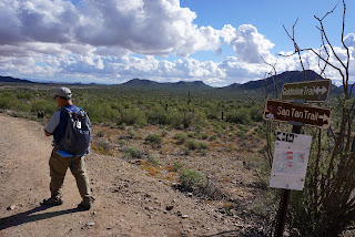
We turned left on San Tan Trail to return to the Goldmine Trail. After following Goldmine, we turned onto Littleleaf trail back to the trailhead. 7.2 miles.
On our way back on Phillips Road, the GPS had us turn right onto N. Thompson which turned into N. Brenner Pass Road. We turned left onto W. Judd Road, then turned Right onto Gary Road. The GPS took us to E. Magma Road, and around a traffic circle staying on Magma Road. We turned right onto W. Hunt Highway. We turned right onto Attaway Road, then on Highway 287 (this turns into 87) then turn left to Signal Peak Road, right onto Woodruff Road and left to N. Overfield Road and right to Cottonwood, and back to the park.


.JPG)


No comments:
Post a Comment